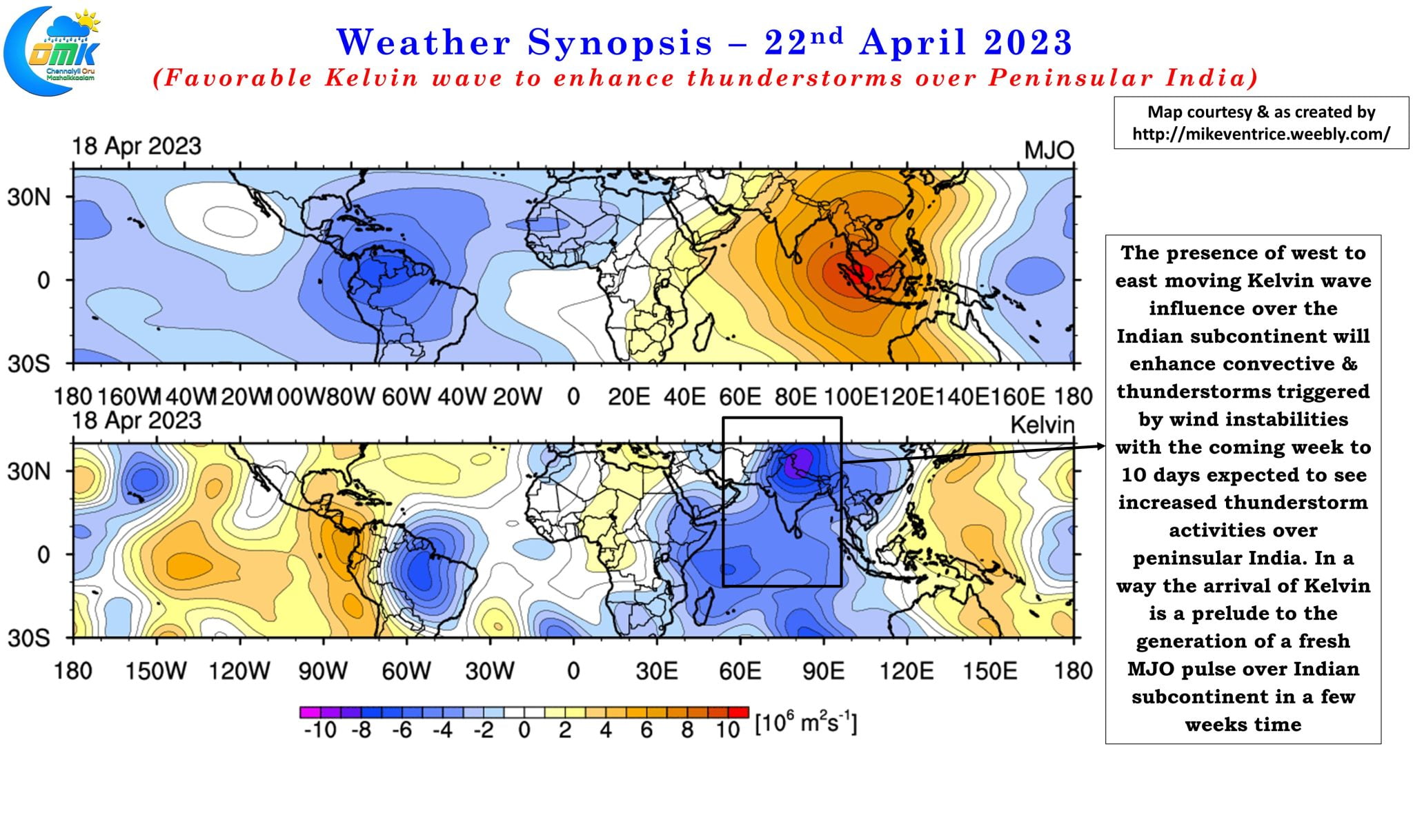
The past week to 10 days saw parts of the Indian Sub Continent come under increased maximum temperatures around East India and Peninsular India. Northeast India in particular was abnormally hot during the day time with many places recording max temperature anomaly in excess of 5°C during this period. Tamil Nadu was no different with places like Karur Paramathi, Erode recording 41°C or more while places like Salem, Trichy, Madurai & Vellore recorded 40°C or more. The good thing though is after a week or so of relentless heat the next week or two could bring about a phase of weather influenced by thunderstorms and rains over most parts of the Indian sub continent.
April so far has been poor on the rainfall front with most parts of the country receiving below normal rains except a few pockets in NW India and Coastal East India. The excess rains received during the month of March 2023 in a way has compensated the sub par April with the seasonal (Summer) rainfall accumulation remaining below normal only in 6 sub divisions of the country on a whole. The areas that benefit the most from pre monsoon thunderstorms in Kerala, Karnataka were among those that has been short changed so far.
The role of wind induced instabilities can never be discounted in setting up things for summer thunderstorms along with day time heat that provides for convective development. But if one were to look deeper any enhanced phase of thunderstorms is more often than not accompanied by larger scale planetary wave support. It is in this context the presence of the West to East moving Kelvin wave becomes important. A positive phase of Kelvin wave enhances thunderstorms over Peninsular India when the base conditions are set up by wind instabilities / convective developments during the day. In a way the passage of Kelvin wave is a prelude to the generation of a fresh pulse of MJO over the Indian Subcontinent.
The rest of April looks good for most parts of Indian subcontinent and yesterday’s thunderstorms over many places of Peninsular India pretty much set the ball rolling for this enhanced phase of thunderstorm activity. Ensemble weather forecasts indicate this enhanced phase of thunderstorms to persist until possibly 2nd week of May before a spell of dry weather takes over Indian sub continent which needs to be closely monitored on how it impacts the seasonal change to Southwest Monsoon. Mid May is also the time to watch out for potentially a pre monsoon cyclone, a critical component, in changing the wind regime to West from East.
As is the case with Summer thunderstorms the bulk of the rains happen where wind instabilities persist. This gives an advantage to places closer to the Ghats and west coast where the temporary westerlies provide a zone of wind convergence giving the right platform for convective development during the day to become thunderstorms. West interior TN, parts of South Interior TN and a few places in NW interior TN closer to the Easter Ghats are the best spots to take advantage of this spell of thunderstorms. Places closer to the coastline like Chennai have an inherent disadvantage during times of transition with unfavorable wind pattern. Due to weak steering more often than not thunderstorms are mostly stationery or in some cases make slow movement further inland rather than coming closer to the coast.
Nevertheless there could be some surprise developments closer to the coast that not only provide respite from the heat but also bring a spell or two of rains.


