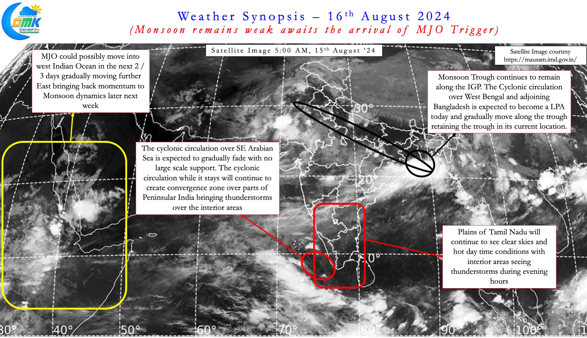
Southwest Monsoon over the past few days has been weak with thunderstorms dominating most parts of the Indian sub continent. The daily rainfall chart while not indicating a classic “Break in Monsoon” period does show below average rainfall status. On the other hand the daily rainfall chart for TN & PDC has saw 11th straight day of above average rains yesterday. The biggest beneficiary of the weak monsoon conditions was the interior areas of Peninsular India. Initially it was the leeward plains of TN that saw widespread thunderstorms. Gradually as the cyclonic circulation over Comorin Sea moved into Arabian Sea thunderstorms picked up over Karnataka and Kerala.
The intra-seasonal oscillation is an integral part of the Indian Summer Monsoon. Last year the first Break in Monsoon period started during early August and continued for most of the month. This year though Monsoon has been weak it has not evolved into a classic Break in Monsoon period. So far this year only on 2 occasions the Standardized Rainfall Anomaly has crossed 1 for three consecutive days. Similarly only on 11th July the Standardized Rainfall Anomaly has dipped below -1.
Over the past few months MJO has been struggling against the transition of Base state from El Nino to La Nina. Way back in April most weather models estimated a 60% chance for La Nina by June-August quarter. The transition from El Nino to La Nina was not as quick as models estimated. The latest outlook indicate a 49% chance for La Nina during August – October quarter. It’s worth studying if the overall ocean warming is likely to bring about slower transitions from now on. This slower transition has effectively disturbed MJO propagation around the globe. Not only the MJO is not making its global circuit in a regular manner but the intensity has also suffered.


Two weeks back a fresh MJO pulse was expected to start a global circuit from Indian Ocean by August middle. As has been the case for the past few months MJO has struggled to put together a cohesive move across Western Hemisphere. It is now likely MJO may emerge over West Indian Ocean in 2 / 3 days time. Gradually it is expected to move across Indian Ocean over the next 2 / 3 weeks. This phase may bring back monsoon dynamics with a Monsoon low forming over Central Bay towards last week fo August. The caveat though is MJO may not be as strong as what models expected a couple of weeks back.
The current cyclonic circulation over Gangetic West Bengal may descend into a Monsoon Low today. As it travels along the monsoon trough it may hold the monsoon trough along the Indo Gangetic Plains. This could mean monsoon may remain weak over Peninsular India until later next week. During this period primarily thunderstorms will drive the rains over Peninsular India. With temporary Southerlies / Easterlies on account of Circulation over Arabian Sea interior areas may benefit the most.
Coastal areas like Chennai may need to wait until westerlies streamline once again. The period just before the possible Monsoon low over Central Bay may bring back thunderstorms for places like Chennai. Alternatively if the Cyclonic circulation over SE Arabian Sea fades away quickly it may open up a window of thunderstorms for coastal Tamil Nadu. Until then hot afternoons, humid evenings with some isolated thunderstorms is all Chennai can look forward too.

