While Northeast Monsoon continues to be in subdued mode over large parts of Tamil Nadu the last couple of days have seen a sense of panic happening not o nly among weather watchers but common pubilic as well about a possible failure of Northeast Monsoon this year. While this sense of panic is very valid on the back of a disaster Monsoon last year it may make sense to keep a more fair perspective rather than just panic. Through this post we will try to give a sense of statistical perspective that we hope will go some way in addressing some of the unnecessary panic reactions.

Rains continue remain isolated in a few pockets of South TN and in West Interior TN along the ghats. Not often one sees Coimbatore AP score possibly what could be the highest 24 hour rainfall among IMD observatories during November. As of 5:30 AM today morning it has scored 52 mm which is the highest 24 hour rainfall during the month of November since 2011. Today also we are likely to see similar conditions with places along the Western Ghats in South Tamil Nadu, West Interior TN & parts of Kerala likely to get moderate rains with isolated places getting heavy spell of rains later in the night.

On the current weather synopsis satellite image indicates Very Severe Cyclone Maha has intensified over the Arabian Sea now sporting a clear eye. It is likely to attain peak intensity before losing shape and strength as it starts to drift as a weak disturbances towards Northwest India under the influence of the incoming Sub Tropical Westerly Trough. Over the Bay the UAC over North Andaman Sea is expected to become a LPA by tomorrow. While weather models indicate the disturbance to move in a NW direction as it intensifies in the open Bay waters it makes sense to wait until it surfaces West of Andaman Islands as the land interaction over A&N Islands will not only impact the potential intensity of the disturbance but also a possible wobble & associated relocation as well.
As we mentioned in the opening remarks of today’s post there is a sense of panic among many about a possible failure Monsoon season for Chennai. Weather is indeed dynamic and things change day to day and events on a global scale certainly play a role on how things shape up for us as well on the monsoon front. While models may not be showing a very optimistic picture considering we are just into the first week of November and even for a place like Chennai there is at least another 30 – 45 days to go for Monsoon to end it makes sense to wait rather than show absolute panic.

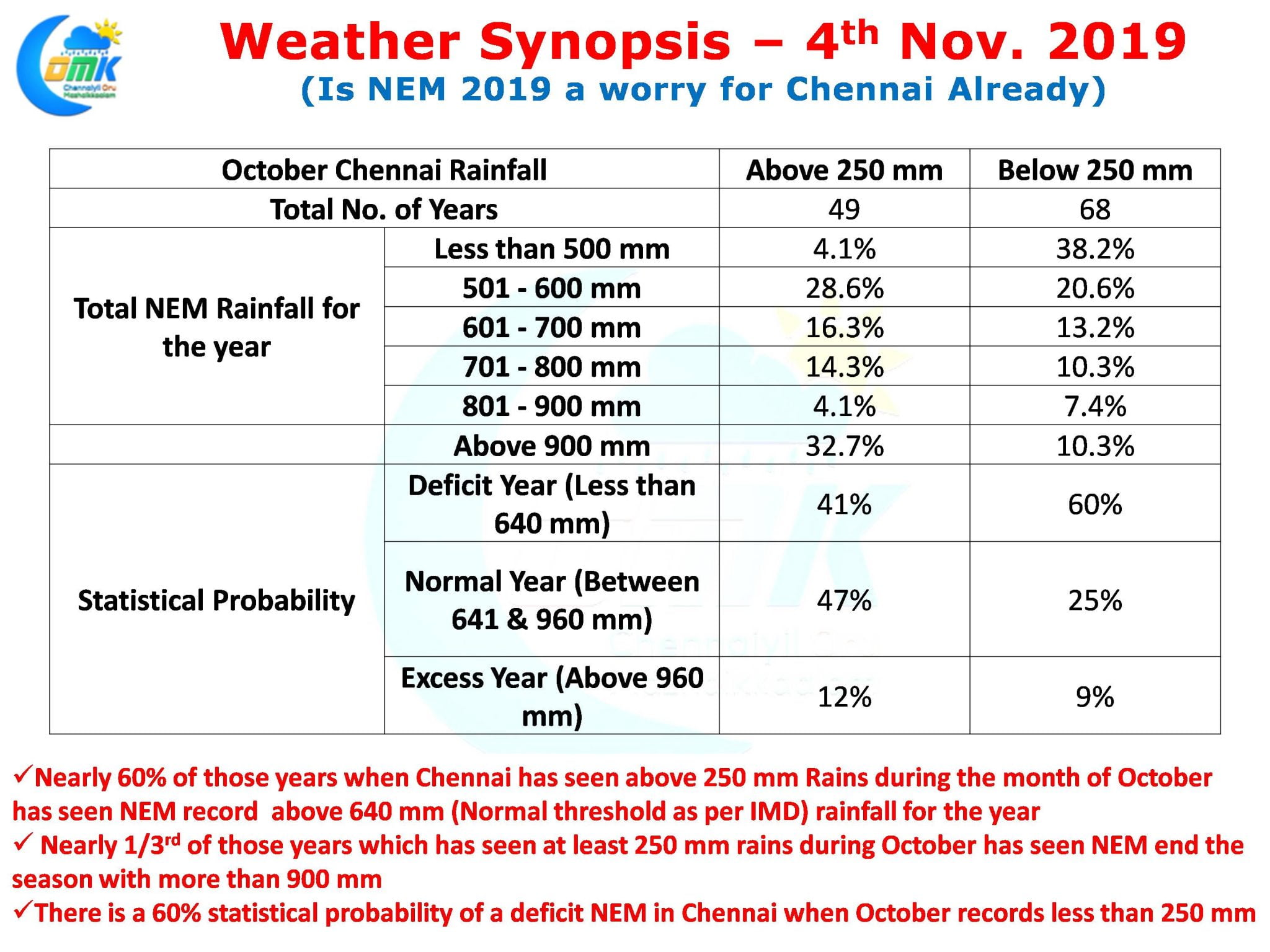
If one were to look at past history and try to put up a statistical analysis things certainly look good for a normal monsoon at Chennai. As we all know for the month of October both the IMD observatories of Chennai has crossed 300 mm of rains. Taking this into account we have tried to identify statistical probabilities of an Excess, Normal & a deficit Monsoon for Chennai based on IMD Regional Classification on an average rainfall of 800 mm during Northeast Monsoon season.
- Nearly 60% of the years when October has scored 250 mm or more overall Northeast Monsoon rainfall has been a normal or better year.
- To the contrary 60% of those years when October has not recorded at least 250 mm has ended as a deficit NEM year overall for Chennai
- Nearly 1/3rd of those years that saw October record at least 250 mm the overall rains for Chennai during Northeast Monsoon has been above 900 mm once again indicating a good statistical probability of a Normal or better monsoon year for Chennai.
The Man who laughs last laughs best goes the saying. With Weather more often than not it pays to practice this rather than panicking early.


