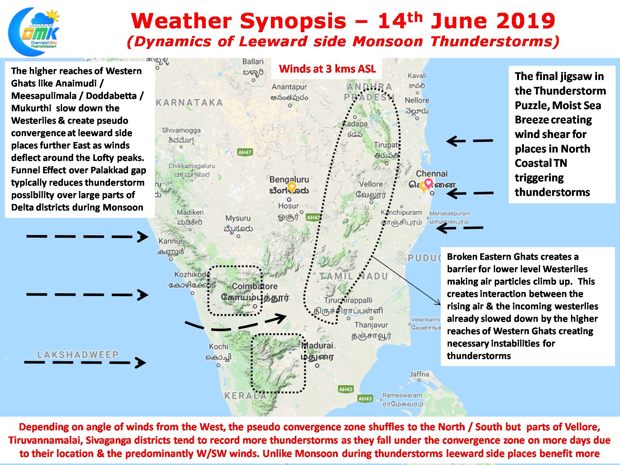
Veppa Salanam thunderstorms as they are called often in Tamil Nadu is a weather event that always fascinates weather bloggers across the Indian Sub Continent. Pre Monsoon & Post Southwest Monsoon thunderstorms follow a pattern of forming around the Convergence Zones triggered by the seasonal wind changes, as the wind pattern shifts East to West / West to East the convergence zone also keeps oscillating across the Peninsular India.
But Monsoon thunderstorms are a different animal all together with more factors that influence thunderstorm development. On the one hand strong Westerlies, put into the mixture two diagrammatically different Mountain Ranges, hot day time conditions aided by clearer skies and finally the arrival of sea breeze filled with lower level moisture in some days.

Yesterday we saw the start of Monsoon thunderstorms over a few places of Tamil Nadu. Places in Tiruvannamalai, Villupuram, Kanchipuram districts recorded moderate rains while some parts of Chennai recorded drizzles / light rains especially in the Northern & Southern suburbs. Today also we are likely to thunderstorms in parts of North TN and few places in the Delta / Pudukottai / Sivaganga region. Weather models indicate W/SW upper level Westerlies while a moderate to strong sea breeze from the East is likely to trigger lower level convergence creating atmospheric instability for thunderstorms to develop.
So we come to the bigger question, why is it often the same set of places get these monsoon thunderstorms? As mentioned earlier Monsoon thunderstorms are complex hence the reason why even the best weather models dont tend to be accurate always. There can never be a definitive answer on why only a certain set of places always based on our understand we try to explain a few factors that play a key role in the development of monsoon thunderstorms.

The purpose of this post is not to address the technical aspects like PBL / Adiabatic Lapse Rate etc but more like a few causative factors that create the right conditions for development of thunderstorms.
- Westerly winds along with Western Ghats will remain an important part of the Monsoon Thunderstorm puzzle. We all know Tamil Nadu falls on the leeward side hence Southwest Monsoon is notional for large parts of the state. But we believe some of the peaks over Western Ghats play a constructive role in the thunderstorm development by slowing down the Westerlies & creating a pseudo convergence on the leeward side through deflection.
- Broken Eastern Ghats is a vital cog in this Monsoon thunderstorm equation. They tend to provide mechanical lift to the lower level Westerlies allowing them to interact with the incoming upper level Westerlies already slowed down by the lofty peaks of Western Ghats. Due to the difference in moisture / mass between these two sets of air particles unstable conditions are created triggering thunderstorms. If one observes carefully places around Tirumala Hills / Nagalapuram / Kalvarayan Hills / Yelagiri / Jawadhu Hills tend to see thunderstorms early aided by the lift provided by the broken Eastern Ghats.
- Similarly Day time convectional heating also provides lift to air particles, a couple of years back when Chennai recorded nearly 43ºC a localized thunderstorm developed around Red Hills completely developed through convectional surface level heating.
- For places like Chennai the biggest advantage is the pocket dynamite, Sea Breeze, when Westerlies slow down allowing sea breeze intrusion to happen, it brings along with it a lower level convergence & moisture as well providing right conditions for thunderstorms to develop. Its been observed those days when sea breeze front intrudes all the way to about 50 kms West of Chennai thunderstorms have developed more often. Also along with the intrusion the angle of entry matters as well. The rough inference is upper level westerlies & lower level sea breeze should interact at right angles and not collide head on for thunderstorms to develop.
Its difficult to put an equation to the above causative factors, but when most of the above factors fall in place then we can be positive of thunderstorms happening that day.


