
Be it weather enthusiasts or professional meteorologists weather events that are historic always sets the butterflies in the minds. One such event has currently unfurled over the Arabian Sea. Over the past 125 years or so since IMD has started keeping records of Cyclones over North Indian Ocean Basin two simultaneous cyclones have never happened either at Arabian Sea or Bay of Bengal.While in the past we have seen instances of twin cyclones over Arabian Sea & Bay of Bengal at the same time, the most recent being Titli & Luban during October 2018, the individual seas have not hosted simultaneous cyclones ever since 1891.

COMK had carried a study last year on the past instances of twin cyclones over North Indian Ocean Basin. Only one instance of twin disturbances in the same sea has happened ever. December 1972 saw a Cyclone heading towards TN coast when simultaneously a depression moved into Andaman Sea from South China Sea. This is the only case of twin tropical disturbance at the same time over either Bay of Bengal or Arabian Sea.

While the historical event certainly gives a sense of high for weather bloggers one cannot ignore the fact as a disturbance Cyclone Maha has given benovolent to Tamil Nadu without doubts. It has given two good days of Northeast Monsoon for Tamil Nadu due to the moisture drag it created over Peninsular India. Yesterday also saw wide spread rains over Tamil nadu with many places in South TN recording heavy rains.

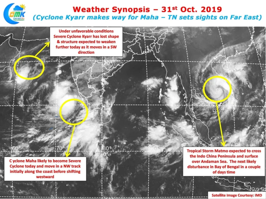
Cyclone Kyarr which was a Super Cyclonic Storm till day before yesterday has collapsed as remarkably as it intensified which is the case with most disturbances in the Arabian Sea. The collapsing Cyclone Kyarr gave the necessary space & energy for Maha to develop in the process allowing it to now slowly stake claim over Arabian Sea. While some weather watchers expected Fujiwara effect to happen over Arabian Sea, the incredible collapse of Kyarr may mean Maha will have an easy path to intensify and move on its journey.

As far as Northeast Monsoon prospects are concerned rains will ease for a couple of days bringing a much needed break for some parts of the state that saw fairly heavy rains over the last few days. Today we could see some coastal areas record moderate rains in a few places as a Mid level Convergence is seen later in the evening but overall scenario is off reduced rainfall activity over Tamil Nadu through the weekend.
If we look Far East in the Satellite images one can see the remnant circulation of Tropical Storm Matmo making its way over the Indo China Peninsula. This will emerge over Andaman Sea & is likely to be the next pulse to develop over Bay of Bengal. While models estimate it to take a Northward path it makes sense to wait until the pulse emerges in Bay. Looking at the way things have shaped up this Northeast Monsoon Season Expect the Unexpected will be the overall theme for the next incoming pulse too.