The Bay has been keeping weather enthusiasts on tenterhooks with models predicting a wide range of Tracks and Landfall Locations. The earliest landfall is on 7th and the latest is beyond 12th.
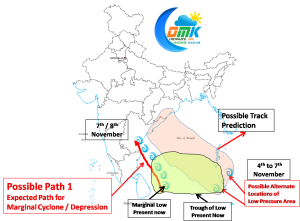
Primarily the confusion stems from the fact that there exists firm possibility of cyclone developing from three different locations. The birth location of cyclones play a very important role on the path they might take and finally the landfall location.
While currently there is a marginal Low Pressure area off the coast of Sri Lanka which was initially expected to dissipate by today paving way for a possible Low Pressure Area off the Andaman Coast. This marginal Low Pressure Area has not gone yet and some models expect it to sustain in the days to come to form a marginal cyclone and cross the coast along South AP. Chennai is guaranteed rains for the next week or so in case this scenario evolves.
If this does not develop over the next 24 to 48 hours then there exists a firm probability of Low Pressure Area forming near Andaman which could possibly intensify into a powerful monster heading towards North AP / Odisha. If this happens then Chennai could face a dry period of no rains for about a week or so.


