The last couple of days saw rains over many parts of Peninsular India. Even a few places around Chennai also saw moderate rains as atmospheric instability triggered thunderstorms. The 45.5 mm accumulated until yesterday puts 2025 as the 14th highest for March rains since 1871 for TN & PDC. These mango showers brought marginal respite from the temperatures that were gradually increasing. With weather models indicating thunderstorms to stick closer to the Ghats the respite was brief. Starting from this week there is increasing indications of Summer 2025 tightening its grip over most of Tamil Nadu.
Sub seasonal models indicate wet weather in the form thunderstorms may stick to Peninsular West coast and adjoining areas. At the same time drier weather conditions may prevail over Peninsular East coast and adjoining areas. This could mean we may see the first active phase of Summer 2025 over most parts of Tamil Nadu. Operational weather models indicate parts of Rayalaseema, Telangana and Coastal AP may be the hottest areas in Peninsular India. As is always the case when Rayalaseema heats up the adjoining areas of North Tamil Nadu also feel the effect.


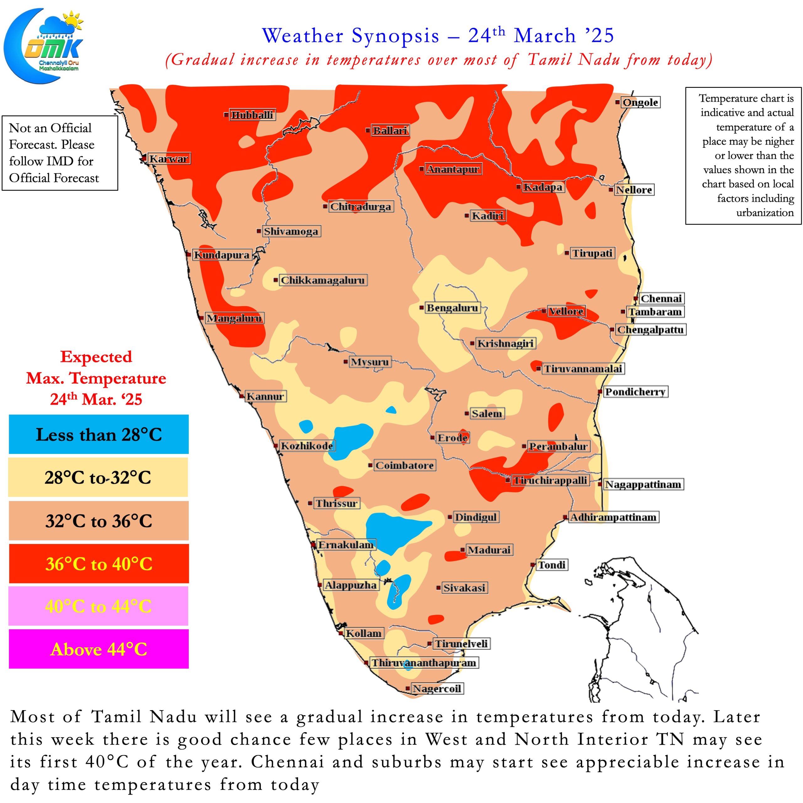
Starting from today the day time temperatures over most parts of Tamil Nadu is likely to increase. From tomorrow / day after an appreciable increase is likely. Later this week between Thursday and Saturday day time temperatures across the state may hit 2 – 4°C above normal. A few places in North Tamil Nadu may see 3 – 5°C above normal temperatures during this period. The drier weather conditions are likely to enhance the heat quotient during the afternoon.
Interior areas of Tamil Nadu and in particular the areas adjoining Rayalaseema and Coastal AP region may be the hottest part of the state. There is a very high chance many placesinterior TN may see the year’s first 40°C this week. There is a slight chance even some of the western suburbs may get closer to 39 / 40°C during this period. The city areas and places closer to the coast may benefit from sea breeze bringing respite.
As has been the case this year right through just as Summer 2025 shows up its first active phase easterlies may offer some solace. Next week once again there could be some thunderstorm / rainfall activity bringing respite. How much of rains and how widespread the respite could be we will get to know later this week. But before that we have face the first active spell of heat this year.