கெடுப்பதூஉம் கெட்டார்க்குச் சார்வாய்மற் றாங்கே எடுப்பதூஉம் எல்லாம் மழை. This couplet about rains by Thiruvalluvar holds good for River Cauvery as well. “Rain by its absence ruins men; and by its existence restores them to fortune.” if we replace the word rains with Cauvery the couplet will still convey its message effectively. In our blog posted dated 13th July we had suggested how Mettur could possibly see its best inflow of the season. After a weak start Southwest Monsoon certainly picked up pace from 2nd week of July. The daily time series for Southern Peninsular India also confirm the uptick in monsoon dynamics over the last few days.
Over the past week ending 17th July the cumulative net inflow into the Cauvery basin dams of Karnataka is about 2.8 lakh cusecs. In storage terms it is almost 25 TMC of water. From 14th July Kabini has started sending pretty much its entire inflow on its way towards Mettur. Harangi opened its crest gates on 15th July and started sending all its inflow towards KRS dam. KRS and Hemavathi dams, the bigger ones in the Cauvery Basin for Karnataka, are on their way to FRL. Based on inflow estimates for the next couple of days latest by Sunday we can expect both these dams to reach FRL.


That would mean effectively starting from Sunday almost all of the inflows, except for canal discharge for agriculture, will flow into Mettur. Exactly a year back on 18th July the storage at Mettur was 36 TMC with a daily outflow of 10000 cusecs for Delta farmers. Today the storage is likely to be around half of it but the crucial thing is while 2023 saw storage gradually go down this year it is the start of the best phase of inflow into Mettur.
The effect of the past 24 hours very heavy rains around Kabini catchment yet to reflect in the shortfall and another 24 to 36 hours of widespread very heavy rains is still left. Based on this there is fair confidence the storage at Mettur on 26th July will touch 60 TMC (+/- 5 TMC). This could mean Tamil Nadu government can start planning water release from Mettur with sufficient scope for maintaining a storage of 60 TMC while maintaining an outflow of between 5000 to 10000 cusecs by matching outflow with inflow during the rest of the Southwest Monsoon season. As the soil gets soaked continuously from now on each cm of rainfall may bring in more inflows compared to similar rainfall say a month back. So sustained moderate to slightly heavy rains is more than sufficient to bring in 10000 cusecs inflow over all on a daily basis.
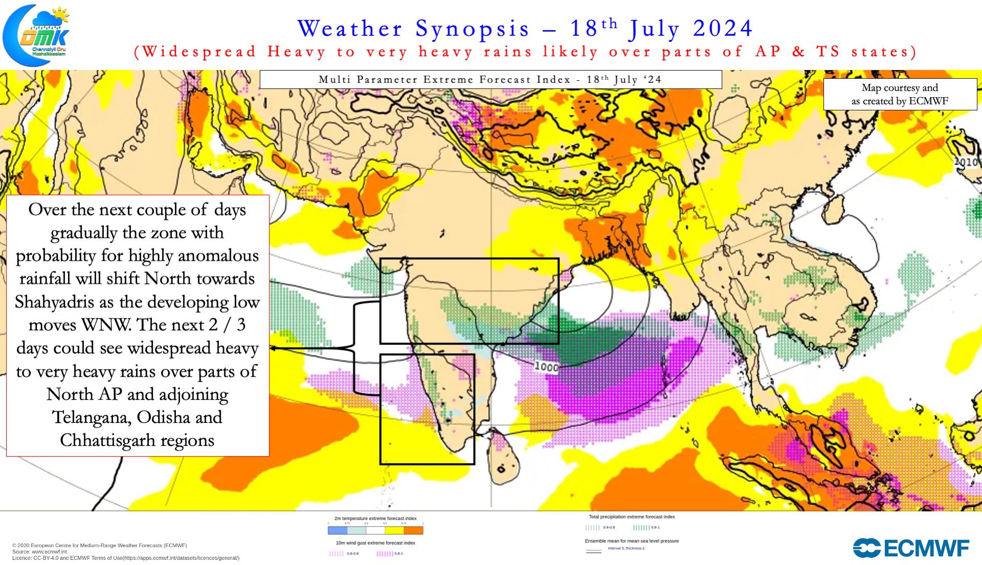
On the weather front with the next LPA expected to form within the next 24 hours Monsoon will continue to remain vigorous. The slight difference between the last few days and upcoming few days is a northward progression of the heaviest rainfall zone. The developing low is expected to move in a WNW direction pulling the Monsoon trough north to its normal position along with it. This could mean parts of Konkan, Central India and adjoining ares of IGP may receive the best rains . This certainly does not mean southern parts of Peninsular India will see a cessation of rains. Instead of the widespread very heavy rains and extremely heavy rains which we saw the rains would be moderate to heavy at most places. Enough to ensure good inflows into the Cauvery basin to keep the farmers happy.
Western Ghats over Karnataka, North Kerala and parts of Tamil Nadu will see another 24 to 36 hours of widespread heavy to very heavy rains before gradually reducing. Leeward areas of Tamil Nadu like Chennai may see pleasant weather conditions with occasional drizzles / light rains for the next couple of days. Over the next couple of days parts of AP, Telangana, Odisha and Chhattisgarh may come under widespread heavy to very heavy rains as the Monsoon low starts moving towards the mainland.

