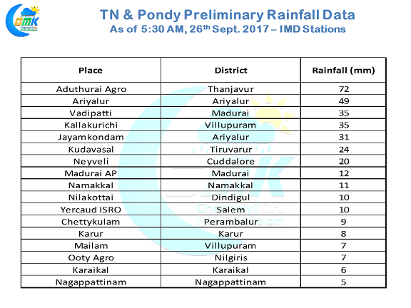
In line with expectations interior areas of South India continue to record good thunderstorm activity as yesterday parts of South Interior Karnataka, Interior Tamil Nadu recorded late evening / midnight storms at many places. Coastal Andhra Pradesh saw light to moderate rains continue over many places right through the day yesterday.
In what could be possibly one of the best Southwest Monsoons in recent times for Delta districts yesterday also saw many places get good rains with the highlight being Aduthurai Agro in Thanjavur district recording 72 mm by 5:30 in the morning including 51 mm in two hours between 8:30 and 10:30 PM. Ariyalur & Perambalur districts continued to get good rains for the second straight day along with Delta districts.
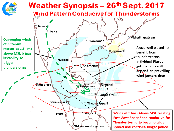
The overall environment over Peninsular India continues to be conducive for thunderstorms with both lower level and mid level winds coming to the aid of thunderstorm development. At Mid Tropospheric Levels there exists a East West Shear Zone over Tamil Nadu latitude that provides the right environment for thunderstorms to survive and become wide spread as the night progresses. The lower level wind pattern shows convergence over parts of Peninsular India particularly in the interior areas providing the instability for thunderstorms to get triggered.
South Interior Karnataka, adjoining parts of Rayalaseema, interior districts of Tamil Nadu in the West & North are well placed to benefit from these thunderstorms. Coastal areas between Adirampattinam & Chennai can get benefit from the interior storms moving towards the coast though which part of the coastal stretch gets the rains will depend on where the interior storms initially forms and how the subsequent wind pattern nudges it along from West to East.
Powered by WPeMatico


