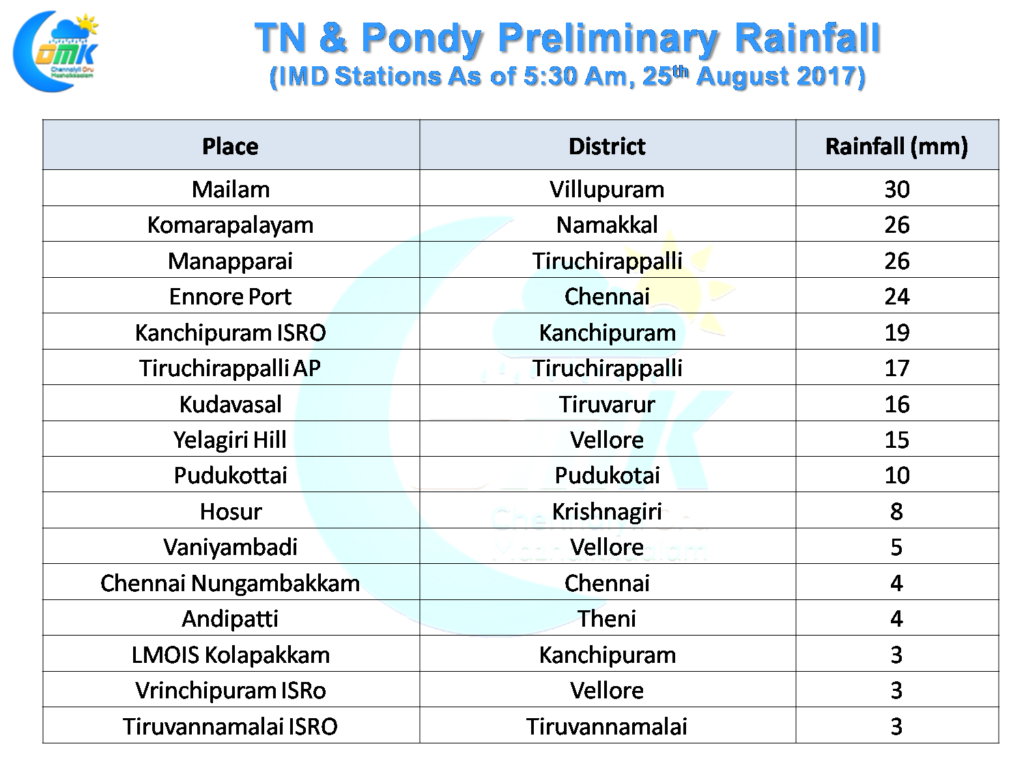
As Chennai gets ready to celebrate Vinayagar Chaturthi early morning drizzles will set the pattern for the city as remnant thunderstorms from the interiors cross coast providing some rains to the city as few places have recorded moderate rains as well around Chennai. Ennore Port recorded 24 mm and Kanchipuram ISRO clocked 19 mm as we made this post. The IMD AWS at Nungambakkam was ticking at 5 mm as we write.
With light to moderate rains expected to continue for the next couple of hours drizzles are likely during the morning hours across most parts of Chennai with one or two moderate spells at times. Cloudy conditions are likely to hold fort for most parts of the day till afternoon making it a pleasant day till noon with temperatures under control. Possibly high clouds could keep things slightly on the humid side as the day progresses.
 With the Upper Air Cyclonic Circulation off the coast of AP / Odisha intensifying things are looking good for the the next Monsoon Low to form in the next 24 to 48 hours or so. This consolidation period represents the best chance of rains for Chennai and most of Tamil Nadu before things slow down. Going by model outputs possibly today represents the best chance for one final spell of good rains for Tamil Nadu before this amazing August comes to an end in terms of rains.
Today also is expected to be another good day of rains for Andhra Pradesh though the heavier rain bands are expected to slightly move up North bringing more rains to Coastal AP under the influence of the evolving monsoon disturbance. While Chennai could see some spell of rains later in the evening if things work out, cloudy conditions could mean a poor sea breeze front and possible missed opportunity on coastal convergence triggering localized developments. Like today some of the remnant thunderstorms crossing coast could give a spell or two of rains though. The best spells of rains though will possibly stay north of 13N
Powered by WPeMatico


